The Top 10 Highest Peaks In Europe You Can Climb
Europe, with its diverse topography, is home to some of the world’s most iconic high-altitude summits. Peaks like Mont Blanc, Elbrus, and the Matterhorn aren’t just geographically impressive; they also stand as testaments to the spirit of adventure.
With many towering peaks dotting the European landscape, determining which summits to conquer or admire from basecamp becomes a challenge. Are you intrigued by the mystery of the Caucasus range, or is the majesty of the Western Alps calling your name?
Choosing the right peak hinges primarily on the technical difficulty of the ascent, the typical duration of the climb, the accessibility of the base camps and the availability of local and experienced guides to accompany you safely to the summit during the best climbing periods of the year.
While some peaks require rigorous training and proper acclimatization due to their elevation, others might be more accessible for the average traveler, albeit still offering a sense of achievement.
So, if you’re a seasoned alpinist seeking the next challenge, a budding mountaineer eager to make a mark, or a traveler who simply wants to behold Europe’s natural wonders without the climb, there’s a peak tailored for every experience level. Below is a list of the must-visit highest peaks in Europe that are beautiful to climb and look at.
Elbrus Peak, Russia
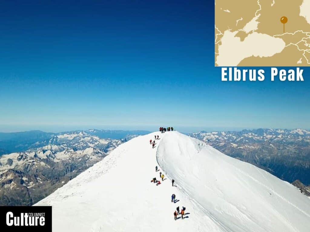
- Elevation: 5,642 meters (18,510 feet)
- Climbing season: May to September
- Ascent duration: 8-10 days
Mount Elbrus is located in the western Caucasus mountain range in Russia, which stretches across Eastern Europe and western Asia. It is the highest peak in Europe, making it one of the Seven Summits—the highest mountains on each of the seven continents. The first ascent was by Killar Khashirov, who reached the eastern summit in 1829.
Elbrus has an altitude of 5,642 meters (18,510 feet). The mountain is a dormant stratovolcano with an almost symmetrical pyramidal shape featuring two main summits; the western summit is 5,642 meters (18,510 feet) and the eastern summit is 5,621 meters (18,442 feet).
The two most popular routes for climbing Mount Elbrus are the South Route and the North Route. The South Route is the more frequented one, as it is considered less technically demanding and has better infrastructure, including a cable car system that can take climbers up to 3,658 meters.
The North Route is less crowded but more challenging, requiring better preparation and more time for acclimatization. For both routes, the level of difficulty is moderate in terms of technical climbing but strenuous due to the high altitude. The climb via the South Route is usually done over six to seven days to allow for acclimatization.
Common base camps for the South Route are located at the Azau Meadow (2,350 meters) or the Garabashi Barrel Huts (3,800 meters). For the North Route, base camps are usually set up at the Emanuel Meadow (2,500 meters).
Dykh-Tau Peak, Russia
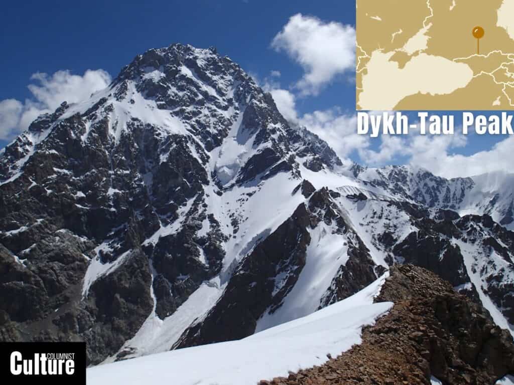
- Elevation: 5,205 meters (17,077 feet)
- Best time to climb: June to September
- Ascent duration: 10-15 days
Dykh-Tau is located in the western Caucasus mountain range in Russia, around three miles north of the Georgian border. It is the second-highest peak in Europe, after Mount Elbrus. The first recorded ascent was made by an Austrian alpinist, Mummery, and two Swiss guides, Zarfluh and Imboden, in 1888.
Dykh-Tau has an elevation of 5,205 meters (17,077 feet) and has a pointed triangular shape with steep ridges. Its challenging technical requirements have made it a less frequently climbed peak compared to others, but it is renowned among climbers for its difficulty and frequent avalanches.
All of the mountain’s faces are incredibly steep and full of snow and ice. The most popular route is the North Ridge, which is still a challenging climb and requires rope skills and expertise in navigating rock and ice. The ascent usually takes around 10–15 days and involves traversing large glaciers, steep snowfields, and vertical rock faces.
Common starting points for the ascent include the Bezengi Alpine Camp, where climbers usually spend around three days acclimatizing before the ascent. A guide with recent experience summiting the mountain is essential, as the weather conditions and climate change can affect the normal routes, making them either impassable or too dangerous to attempt.
Shkhara Peak, Georgia
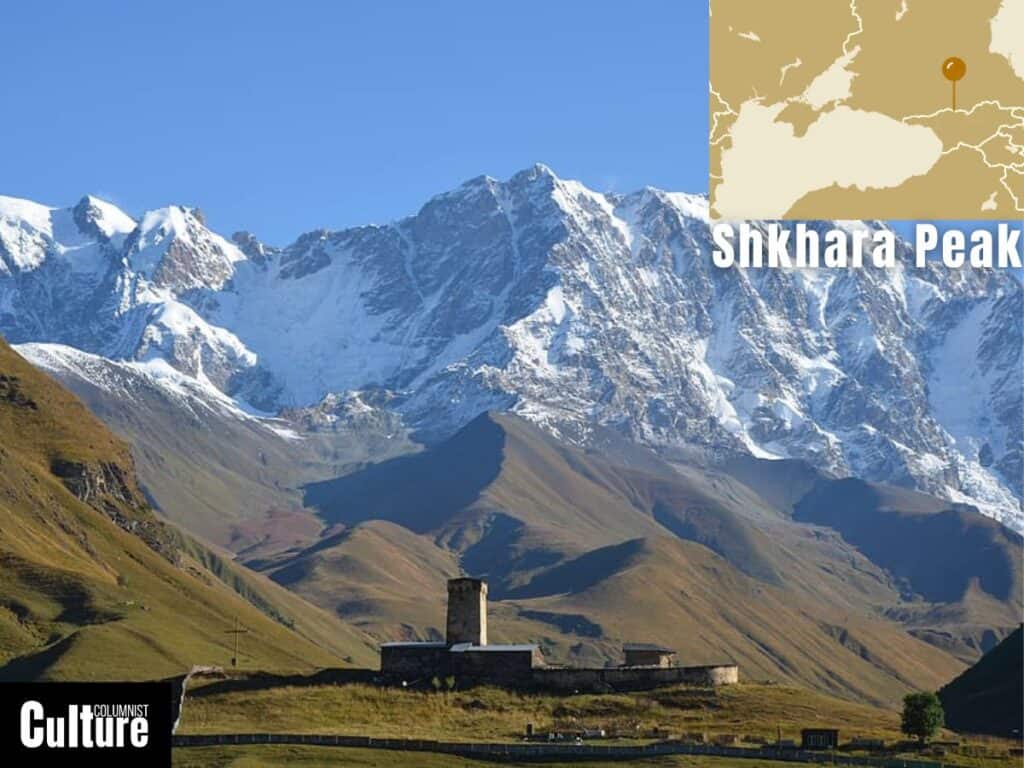
- Elevation: 5,193 meters (17,037 feet)
- Best time to climb: July and August
- Ascent duration: 12-16 days
Shkhara Peak is located in the Greater Caucasus mountain range, straddling the border between Georgia and Russia. It is the third-highest peak in Europe and the highest peak in Georgia. The mountain was first climbed by John Garford Cockin and Swiss guides Ulrich Almer and Christian Roth in 1888.
Shkhara has an altitude of 5,193 meters and is characterized by steep, icy slopes and multiple ridges. The peak forms the highest point of the Bezengi Wall, a sharp 13km ridge that links several of the highest peaks of the Caucasus. The full traverse had never been completed in the winter.
Shkhara has an easier route on the Georgian side, starting from the UNESCO protected village of Ushguli in Upper Svaneti. The Bezengi Wall route, starting from the Bezengi Base Camp on the northern side of Russia, is the most popular route and has more facilities available, including a training room, sauna, gear rental, and safe deposit boxes.
Climbing Shkhara demands advanced technical skills in ice and rock climbing. The ascent typically requires about twelve to sixteen days, while traversing the wall can take around 18 days or more. Taking an experienced and certified guide is essential to taking on this expedition.
Koshtan-Tau Peak, Russia
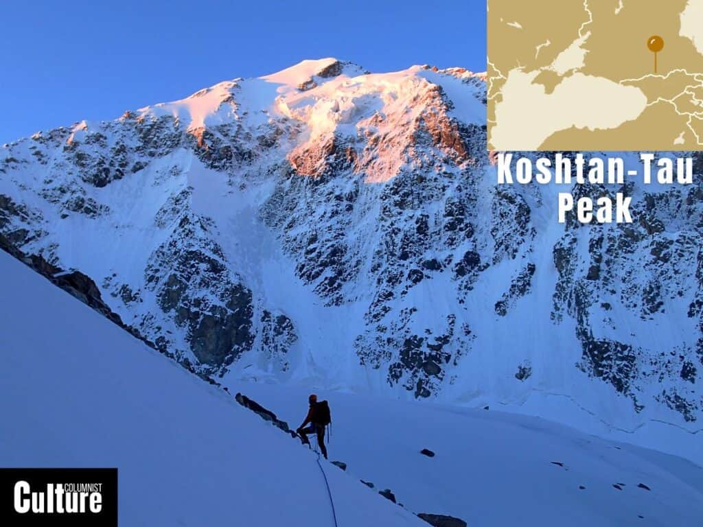
- Elevation: 5,144 meters (16,876 feet)
- Best time to climb: June to September
- Ascent duration: 8-10 days
Kushtan-Tau Peak is located in the western part of the Greater Caucasus mountain range, close to the border between Russia and Georgia and is the fourth-highest mountain in Europe. The first known ascent was made in 1889 by the British alpinist Herman Woolley.
With an altitude of 5,144 meters (16,876 feet), Kushtan-Tau is characterized by steep, rocky faces and glacial terrain. It’s one of the two “Brothers of Bezengi”, marking the eastern end of the Northern Massif, with the other brother being Dykh-Tau Peak.
The peak can be approached from several routes, but most involve technical climbing with a combination of rock and ice sections. The Northern Crest Route is considered the more accessible route, though it’s lengthy and demands endurance. The journey involves traversing the Mizhirgi Glacier, requiring careful navigation due to crevasses and occasional rock-falls.
Common starting points include the Bezengi Base Camp, similar to other peaks in the area. The ascent usually takes around eight to ten days, depending on the weather and conditions. Climbers typically start from Camp Bezengi and can approach Koshtan Tau from either the west or east side of the valley, each offering unique views and challenges.
Pushkin Peak, Russia
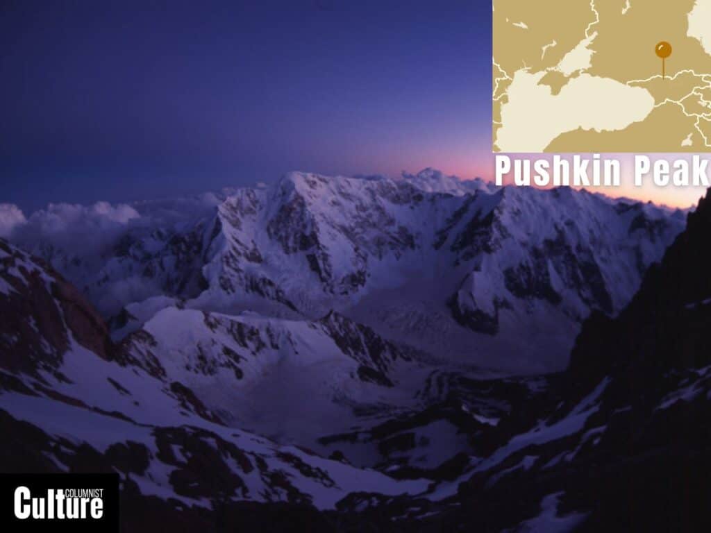
- Elevation: 5,100 meters (16,732 feet)
- Best time to climb: June to September
- Ascent duration: 5-7 days
Pushkin Peak is located in the Dykh-Tau mountain massif in the Bezengi region (Central Caucasus, Russia) between East Dykh-Tau and Borovikov Peak. It is the fifth-highest peak in Europe and is named after the Russian poet Alexander Pushkin. Its first recorded ascent was by a Soviet Spartak team expedition in 1961 led by B. Kletsko (although an earlier ascent in 1937 by Viktor Matveyevich Zimin’s team has not been confirmed).
Pushkin Peak has an altitude of approximately 5,100 meters (16,732 feet) and is characterized by its challenging and technically demanding routes, including steep ice and rock faces, and a propensity for avalanche risks, particularly on its hanging glaciers. Given its lack of documented ascents, there is limited information about potential routes and hazards.
Given that Pushkin has no classified routes, it requires climbers to rely heavily on their mountaineering expertise and instinct. There is a subtle ridge that runs north from the summit of Borovikov Peak, offering a potential pathway for ascent. (documented by Tsibanov Andrey)
The base camp for Pushkin Peak is typically established on the flat area at the very edge of the Toguzak Glacier. Climbers usually start with climbs on lower but technically challenging peaks like Panoramny to get acclimatized. Typically, an ascent to Pushkin Peak can take about five to seven days, starting from the base camp.
Kazbek Peak, Georgia
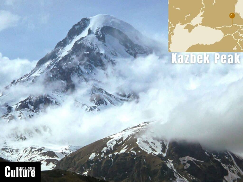
- Elevation: 5,033 meters (16,512 feet)
- Best time to climb: June to September
- Ascent duration: 4-7 days
Mount Kazbek is located in the Caucasus Mountains, straddling the border between Georgia and Russia. The mountain is the sixth highest in Europe, with its first recorded ascent by Douglas Freshfield, Adolphus Warburton Moore, and Charles Tucker of the British Alpine Club in 1868, along with their guide François Devouassoud.
Mount Kazbek has an elevation of 5,033 meters (16,512 feet), making it the third-highest peak in Georgia and the seventh-highest in the Caucasus range. It is a dormant stratovolcano, with its last known eruption occurring around 650 AD. Although Kazbek is considered less technically challenging than other 5,000 meter peaks, a high level of strength and endurance is still required.
There are several routes that can be taken to climb the mountain but the most commonly used route to the summit is the South Route, starting from the Georgian side. This route begins at the town of Stepantsminda and then climbs up to Meteo Station (3650m) with an optional stop at Altihut refuge and then pushes to the summit, where the final meters turn very steep.
Aside from the spectacular views at the top of the mountain, the nearby Gergeti Trinity Church provides a stunning vantage point from which to see and photograph the mountain. The ascent and descent typically take around four to seven days, depending on the weather conditions.
Tetnuldi Peak, Georgia
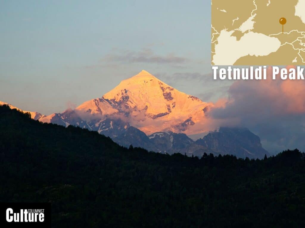
- Elevation: 4,858 meters (15,938 feet)
- Best time to climb: June/July to September
- Ascent duration: 7 to 10 days
Tetnuldi is a mountain peak situated in the Greater Caucasus mountain range of the Svaneti region of Georgia. It is the seventh-highest peak in Europe, with the first recorded climb completed in 1896 by the British mountaineer Douglas Freshfield.
Tetnuldi has an elevation of 4,858 meters (15,938 feet), making it the fifth highest peak in Georgia. The mountain is characterized by steep snowfields leading up to exposed icy ridges, with the landscape becoming more rugged and technical as you ascend.
There are routes on both the south and north faces of the mountain but the Southwest Ridge, known as the Normal Route, is the most common path to the summit as it strikes a balance between technical challenge and accessibility. The mountain’s remote location adds to the sense of adventure but also means climbers must be well-prepared.
The common base camp for Tetnuldi is situated at an elevation of approximately 3,200 meters (10,498 feet) near the Adishi Glacier. From the final campsite to the peak, you gain 1,100 meters in elevation, making the final push a strenuous one. Depending on the pace and acclimatization, the ascent and descent usually take approximately seven to ten days.
Mont Blanc, France
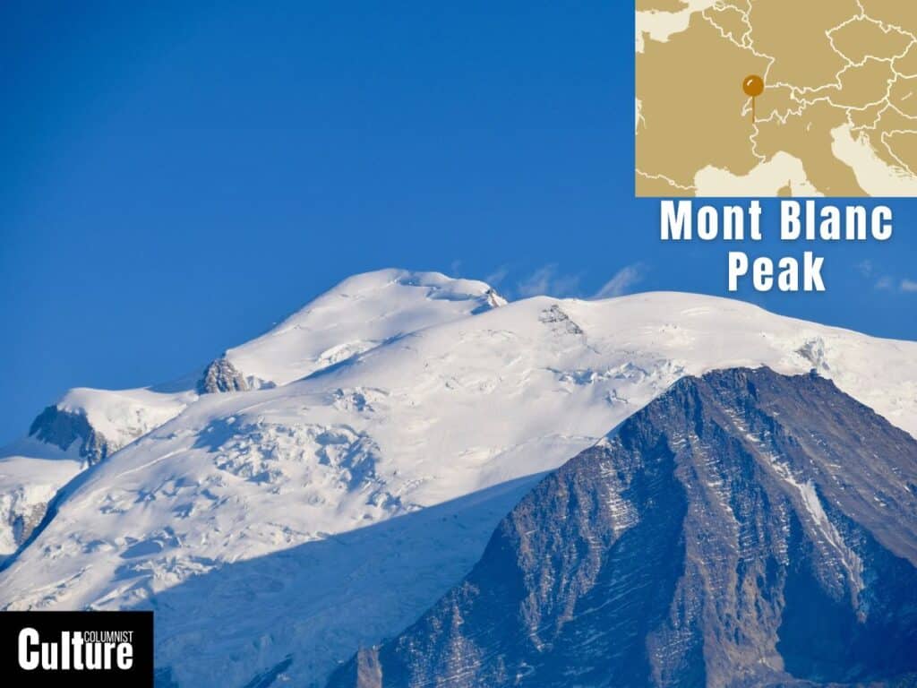
- Elevation: 4,808 meters (15,774 feet)
- Best time to climb: June to September
- Ascent duration: 2-3 days
Mont Blanc is situated in the Alps mountain range on the border between France and Italy. It is the eighth-highest mountain in Europe and the highest mountain in western Europe. The first ascent was made by Jacques Balmat and Michel-Gabriel Paccard in 1786, marking the start of modern alpinism.
Mont Blanc has an altitude of 4,808 meters (15,774 feet) and is composed of granite and glaciers, including the Mer de Glace, one of the largest glaciers in Europe. It is possible to climb the mountain with no technical experience, provided you climb with a professional guide, but a very good level of strength and endurance is also required.
The most popular and easiest route is the Goûter Route, often approached from the French side via Saint-Gervais-les-Bains. Mont Blanc’s popularity can lead to crowded routes during the peak climbing season, which is something to keep in mind if you prefer a more remote experience.
The Tête Rousse Hut and Goûter Hut serve as common base camps. As the ascent and descent can usually be completed in two days, a prolonged acclimatization period is generally not required for those already accustomed to high-altitude conditions. Nonetheless, many climbers opt for a staggered ascent with an overnight stay at a base camp for better acclimatization.
Dzhimara Peak, Russia
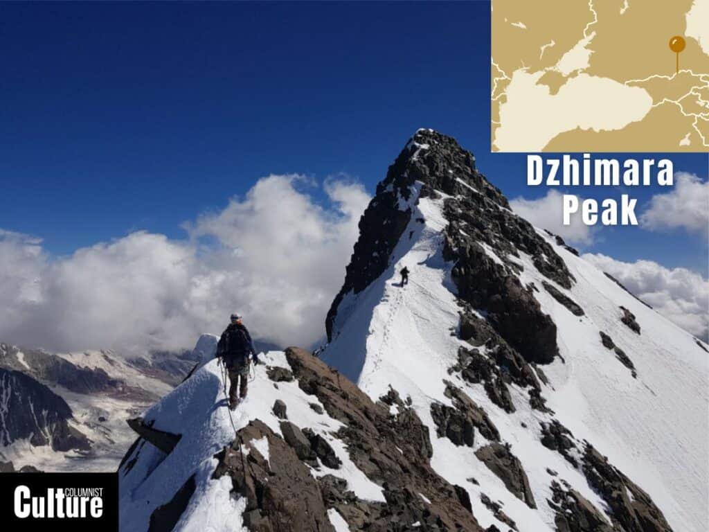
- Elevation: 4,780 meters (15,682 feet)
- Best time to climb: June to September
- Ascent duration: 5-7 days
Dzhimara Peak (also written as Djimara or Jimara) is located in North Ossetia, Russia and is the ninth-highest mountain in Europe. The peak is part of the Khokh Mountains in the Greater Caucasus Mountains, lying between the Black Sea and the Caspian Sea.
Dzhimara Peak has an elevation of 4,780 meters (15,682 feet) and is known for its steep, glaciated slopes and challenging climbing conditions. This peak offers a remote climb that involves a combination of glacier travel, steep rock faces, and high alpine ridges and it attracts skilled mountaineers looking for an adventure that’s off-the-beaten-track.
Dzhimara’s standard route begins at Chegem Gorge but because there are few documented routes and information about the journey, it requires climbers to be skilled and self-sufficient in mountaineering. Depending on the pace and acclimatization, the ascent and descent usually take approximately five to seven days.
Ushba Peak, Georgia
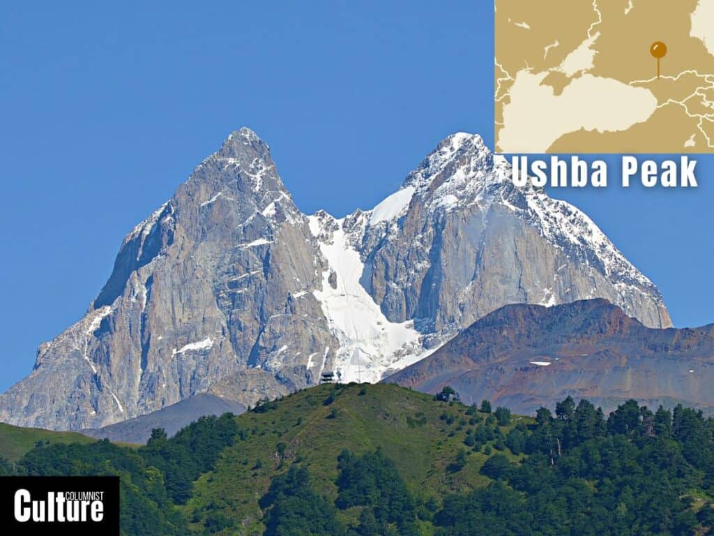
- Elevation: 4,710 meters (15,452 feet)
- Best time to climb: June/July – September
- Ascent duration: 5-7 days
Ushba Peak is located in the Greater Caucasus mountain range, straddling the border between Russia and Georgia. It is the tenth-highest mountain in Europe and is known for it’s distinctive double peak. The first ascent of the north peak was recorded in 1888 by John Garford Cokklin and Ulrich Almer, while the first ascent of the south summit was in 1903 by B. Rickmer-Rickmers.
Ushba’s highest peak, the South Summit, has an elevation of 4,710 meters, while the North Summit stands at 4,700 meters. Although it is not the highest peak, it is considered one of the most challenging due to its steep slopes and unpredictable weather.
There are over fifty routes to the summit, but the most commonly used are the North Route via the Ushba Plateau and the South Gabrieli Khergiani route. The classic route passes over Ushba Glacier, which requires glacier trekking techniques to cross. The mountain has its own microclimate that’s more inclement compared to nearby peaks, making the climb even more difficult.
The climb is usually started from a camp at the base of the peak, with two nights at a bivouac site high on the route. Faster ascents are possible but they involve more difficult routes and free climbing. The climb typically takes about five to seven days, depending on the weather and acclimatization.