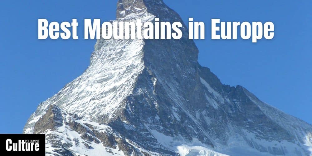
Best Mountains To Visit In Europe
Europe boasts not just iconic mountain ranges but also individual mountains that have their very own character. From the legendary Matterhorn straddling Switzerland and Italy to Spain’s mystical Montserrat, each mountain offers a unique character and story to tell.
The challenge for many adventurers is narrowing down which specific mountains to explore. Is your aim to tackle one of the “Four-Thousanders” of the Alps, or are you more intrigued by lesser-known gems with their own unique myths and local cultures?
The ideal mountain for your trip may hinge on a variety of factors, such as the mountain climate and landscape, the best time to visit, specific viewpoints or features that make a mountain unique, available surrounding amenities like cabins or guided tours, and the types of activities and experiences available.
Whether you’re a roaming mountaineer, a family looking for an unforgettable vacation, or someone in their golden years wanting to check a peak off their bucket list, there’s a particular mountain in Europe that can provide a memorable experience that you’ll treasure for a lifetime. Below is the top 10 list of the must-visit mountains in Europe.
Mount Elbrus, Russia
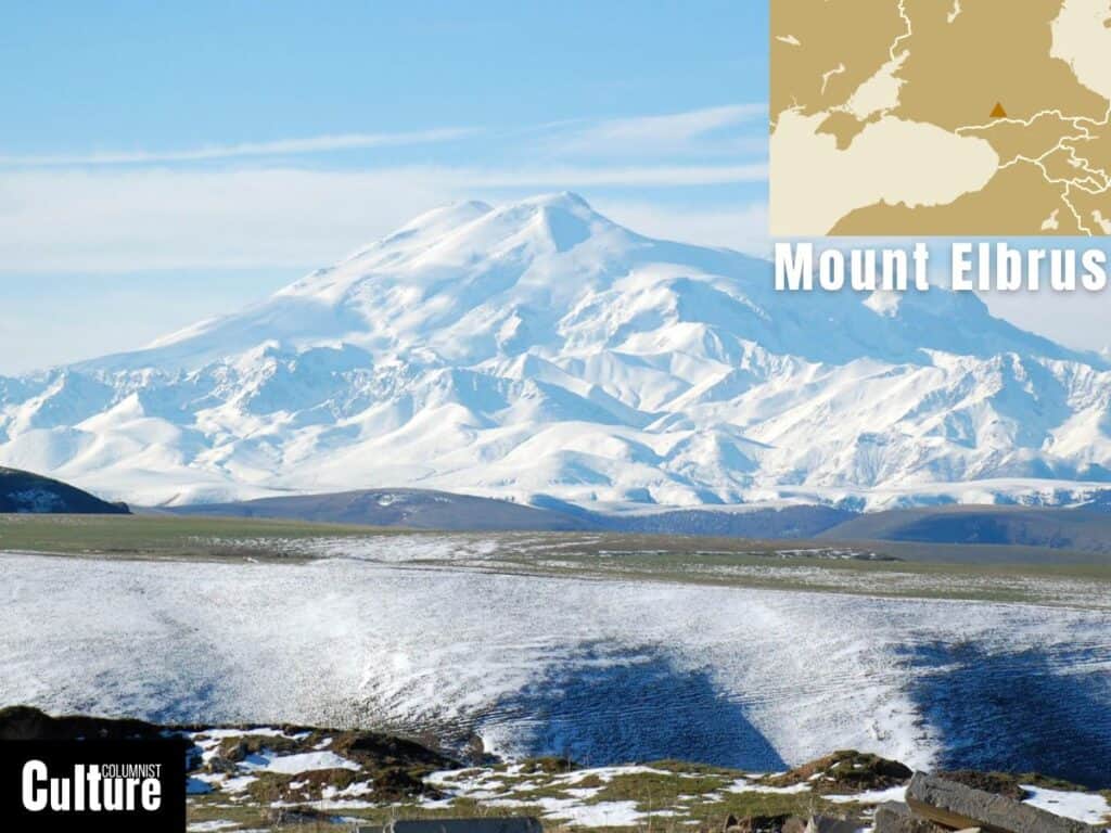
Mount Elbrus is situated in the western Caucasus mountain range in Russia. It’s the highest peak in Europe and one of the Seven Summits, the highest mountains on each of the seven continents.
Mount Elbrus has an elevation of 5,642 meters (18,510 feet) above sea level. It is a dormant stratovolcano, with its last known eruption occurring around AD 50. The mountain is home to 22 glaciers, with the largest one, the Irik Glacier, stretching for approximately 11 kilometers.
Ascending Mount Elbrus is for hard-core climbers only, with two routes that can take around 8-10 days to reach the summit. Otherwise, there are lower-altitude trails, horseriding treks and paragliding tours that can be done as half-day or full-day trips. The mountain is covered in snow year-round, but the summer months offer the best weather to see the mountain from the base.
In winter, the mountain attracts skiers and tourists for the spectacular views from the world’s highest cable car at 3847 meters, called Gara-Bash. While the mountain is snowy year-round, it doesn’t have an extensive ski resort; there is only one piste down along the cable car. This piste is labeled “red,” so it is not the best for beginners but the trip is worth it for the views alone.
Mont Blanc, France

Mont Blanc, also known as “La Dame Blanche” or “The White Lady,” is located in the Alps on the border between the Haute-Savoie region in France and the Aosta Valley in Italy. It is the highest mountain in the Alps and Western Europe and it is often considered the birthplace of modern mountaineering.
Mont Blanc has an elevation of 4,808 meters (15,774 feet) above sea level. The mountain is home to numerous glaciers, the most famous of which are the Mer de Glace and the Glacier du Géant. The most popular hiking routes to the summit include the “Gouter Route” and the “Three Monts Route”. These routes are technically straightforward but require a high level of physical fitness due to the altitude and rapid weather changes.
For those who aren’t necessarily looking to summit the mountain, the Tour du Mont Blanc, spanning about 170 kilometers (105 miles), presents a perfect adventure. This renowned long-distance hiking trail encircles the Mont Blanc massif, traversing through France, Italy, and Switzerland, and is typically completed in 7 to 10 days, offering a spectacular way to experience the Alps without the technical challenges of mountaineering.
Near Mont Blanc is the Aiguille du Midi, a notable peak and vantage point accessible year-round via a cable car that offers one of the highest accessible viewpoints in Europe and a spectacular view of Mont Blanc. The area around Mont Blanc, including towns like Chamonix, is a summer and winter hub for adrenaline-filled outdoor activities known for skiing, hiking, mountain biking, paragliding and rock climbing.
Matterhorn, Switzerland
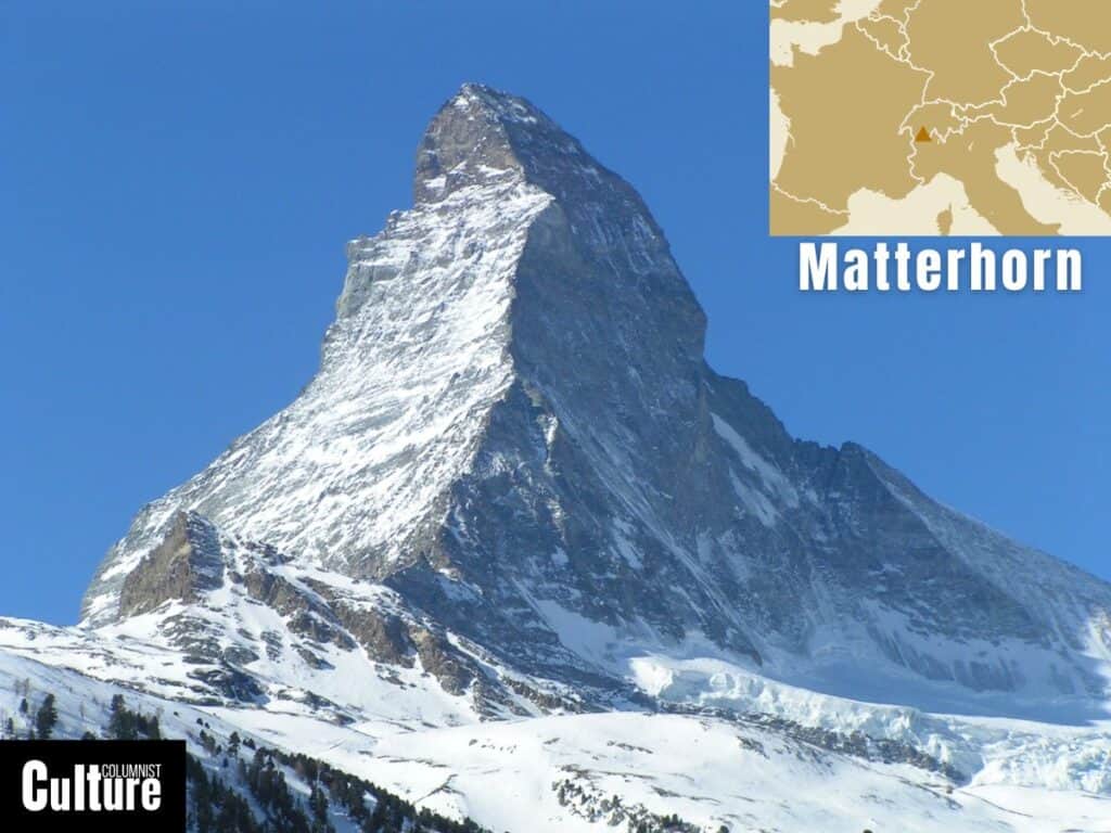
The Matterhorn is one of the most iconic mountains in the world, situated in the Pennine Alps on the Swiss-Italian border. The mountain is not only a symbol of the Swiss Alps but also inspired the distinctive triangular shape of the famous Swiss chocolate, Toblerone.
It has an elevation of 4,478 meters (14,692 feet) and is particularly known for its near-symmetrical pyramidal shape. The mountain is a popular destination for skiers and is home to several glaciers, the largest being the Zmutt Glacier on the Swiss side. The most popular route for climbing the Matterhorn is the Hörnli Ridge from the Swiss side, which is considered a fairly technical climb and the Italian Lion Ridge, which is slightly more difficult but less crowded.
Besides mountaineering, getting to the Matterhorn is an adventure in itself, as their are no cars allowed in Zermatt, the nearest Swiss village. You can take the Matterhorn Gotthard Bahn to Zermatt or the Glacier Express from St. Moritz, both of which offer scenic journeys with views of the mountain as you approach the final stop. The Five Lakes Trail, the Matterhorn Glacier Trail and the Hörnlihütte hiking trail offer easy and scenic trails around the mountain.
To get an unobstructed view of the Matterhorn, take the funicular to the Sunnegga viewpoint. From there, to see Matterhorn set against the majestic backdrop of the surrounding Alps, take a gondola ride to Blauherd, followed by a cable car ascent to Rothorn. Don’t miss the Matterhorn Museum in Zermatt to learn more about the mountain’s history and folklore.
Ben Nevis, United Kingdom
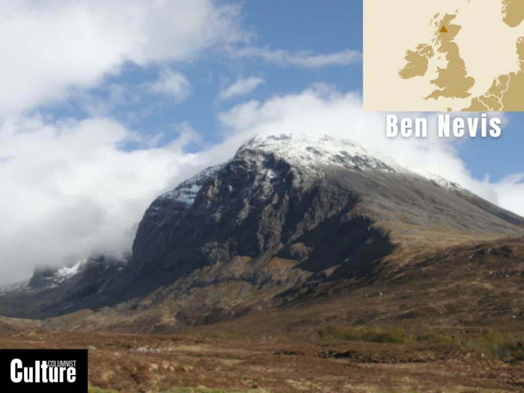
Ben Nevis is the highest mountain in the British Isles, located in the Grampian Mountain range in the Lochaber area of the Scottish Highlands. The mountain was formed from the collapsed dome of an ancient volcano, which can be observed on its north face, where the roof of the volcano collapsed 600m into the hollow magma chamber below.
With a summit elevation of 1,345 meters (4,413 feet), the mountain’s peak is a large stony plateau of about 100 acres featuring four main vertical ridges, making it a well-known destination for rock climbers. The ridges include Castle Ridge, which is 270 meters long; Observatory Ridge, which is 500 meters long; the North East Buttress at 400 meters long; and Tower Ridge at 600 meters long.
Other than the vertical climbing, the most frequented route to reach the summit is the “Mountain Track” (also known as the “Tourist Route”), which starts from the Ben Nevis Visitor Centre. This path is considered the least technical and the most approachable for non-climbers, taking approximately 4 to 5 hours for the ascent and 2 to 3 hours for the descent.
Ben Nevis has several different sides to view it from. A rounded form with a flat mountain plateau can be seen from the shores of Loch Linnhe, southwest of Fort William, while from the banks of Allt a’ Muhuilinn or from the neighboring peak of Càrn Mòr Dearg, you can see the sheer north face of Ben Nevis with its many crags, cliffs, and gullies. You can also take the Nevis Range Gondola up the neighboring peak of Aonach Mòr to access a network of mountain trails and viewpoints to see the more dramatic side of the mountain.
Jungfrau, Switzerland
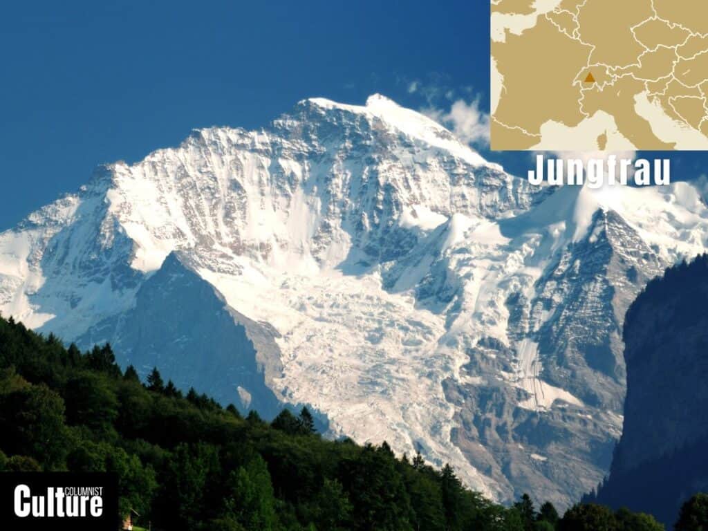
Jungfrau is one of the main summits in the Bernese Alps, situated in south-central Switzerland. It is flanked by two other peaks, the Eiger and the Mönch, which together form a highly recognizable trio of peaks. Its name, meaning “Maiden” in German, is said to derive from legend; it is the “maiden” that is “protected” by the neighboring peaks Eiger and Mönch.
The mountain has an elevation of 4,158 meters (13,642 feet), with an impressive North Face that rises about 3,000 meters from the valley below. The mountain is home to the Aletsch Glacier, the longest glacier in the Alps and a UNESCO World Heritage Site. The most common climbing route to the summit is the Rottalsattel route, which typically takes two-days with an overnight stay in the Rottal Hut.
To experience Jungfrau without needing mountaineering skills, you can take a train journey to Jungfraujoch, Europe’s highest railway station, located below the peak at an elevation of 3,454 meters. There, you can explore the Sphinx Observatory with its panoramic views over the Aletsch Glacier and the Ice Palace with its ice sculptures and tunnels carved directly into the glacier, between the Monch and Jungfrau peaks.
While the mountain is easily accessible from Interlaken, the Swiss villages of Grindelwald, Mürren, and Lauterbrunnen offer close up vantage points from which to see the Jungfrau mountain from below. They also serve as a gateway to access the different trails and attractions on the mountain. However, to get an unobstructed view of Jungfrau, take a tandem paragliding flight on a clear day in summer or winter.
Mount Olympus, Greece
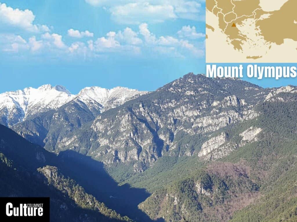
Mount Olympus is the highest mountain in Greece, located in the Olympus Range on the border between Thessaly and Macedonia. In ancient Greek mythology, Mount Olympus was considered the home of the Twelve Olympian gods, making it a prominent site for Greek mythology and archaeology.
Mount Olympus has 52 peaks in total, but the two main peaks are Mytikas, the highest peak at 2,917 meters (9,570 feet), and Skolio, the second highest at 2,911 meters. Olympus is not considered a technical mountain to hike, but the final section is categorised as a YDS (Yosemite Decimal System) Class III rock scramble, meaning handholds and rope attachments are recommended for learning climbers. The entire trek typically takes one to two days.
While there are plenty of adrenaline filled activities to enjoy on the mountain, including trekking, paragliding, canyoning, rafting, climbing, mountain-biking and jeep safaris, it’s recommended to dedicate some time to exploring the mountain’s unique and diverse nature. As a National Park and a UNESCO Bioreserve, Mount Olympus has over 1700 species of flora, 30 species of mammals, 100 species of birds and 18 species of reptiles to discover.
Litochoro, on the eastern foothills, is a commonly used gateway town to the mountain trails with views of the towering peaks. Another unmissable vantage point is that of the Plateau of Muses, which is a grassy high-altitude meadow equipped with two mountain huts, the Christos Kakkalos and Giosos Apostolidis refuges, and ample space for camping overnight. The plateau offers an impressive view of Stefani Peak, which is particularly dramatic during sunrise and sunset.
Puy de Dôme, France

Puy de Dôme is located in the Auvergne-Rhône-Alpes region of central France. It is part of the Chaîne des Puys, a north-south-oriented chain of cinder cones, lava domes, and maars in the Massif Central. The mountain is a lava dome formed by the slow extrusion of highly viscous lava.
With an elevation of 1,465 meters (4,806 feet), Puy de Dôme is one of the youngest and most well-known volcanoes in the Chaîne des Puys volcanic field. Historically, the mountain was a center for religious activity and was dedicated to the god Mercury during Roman times; ruins of a Roman temple can still be found near the summit.
The mountain offers a range of hiking and climbing opportunities, most notably the “Chemin des Muletiers,” a well-maintained trail that starts from the Col de Ceyssat. This path is relatively easy, 3.9 km with a moderate gradient, and takes about two hours to reach the summit. An alternative route is Chemin Chèvres, 4.9 km long, a zigzagging path along the north face that takes about three hours to reach the summit.
Once at the summit of the Puy de Dôme, there are three walking paths: Curious, Conquerors and Little Explorers, with views of the surrounding Auvergne region. The summit itself is home to a meteorological station and the ruins of a Roman temple dedicated to Mercury. The best way to observe the unique formation of the mountain is from the air with a hot air balloon or paragliding tour.
Mount Triglav, Slovenia
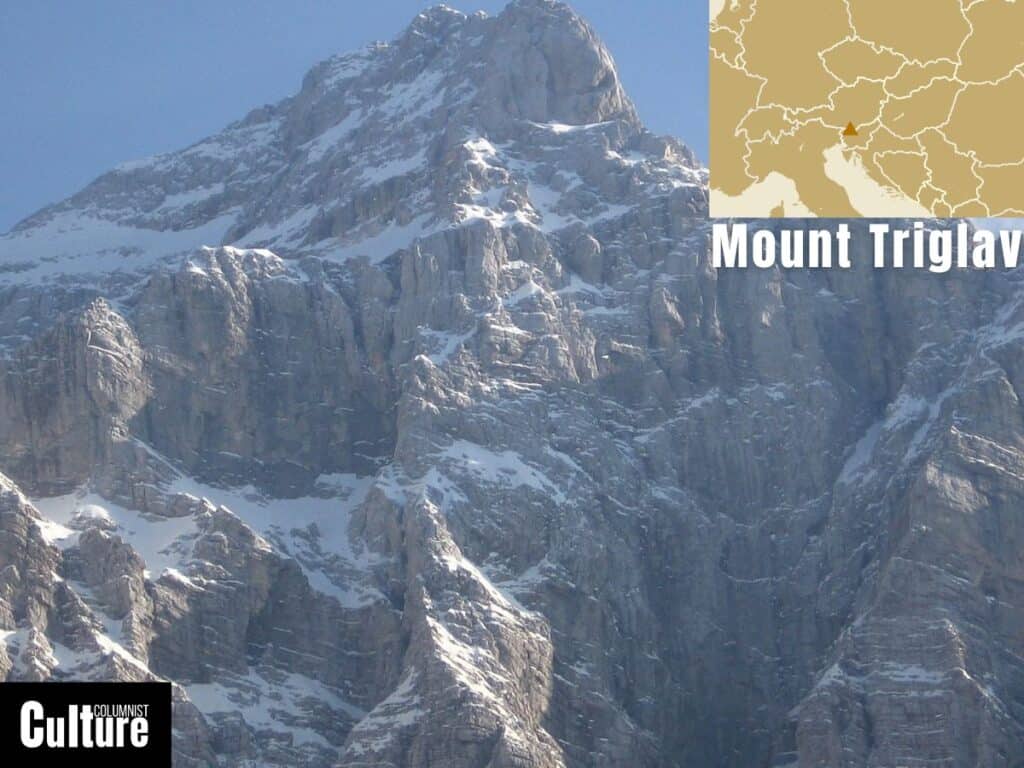
Mount Triglav is located in Slovenia, specifically in the Julian Alps, a subrange of the Southern Limestone Alps. The mountain is an iconic symbol of Slovenian identity and is featured on the country’s coat of arms and flag.
With an elevation of 2,863 meters (9,395 feet), it is the highest peak in Slovenia and the Julian Alps. It poses a technical and physically demanding climb. The most popular and frequently used routes to the summit are the Krma Valley route and the Tominskova Pot route, which is slightly more challenging and includes a traverse of the Triglav North Face. Both routes lead to a final ascent via ferrata that reaches the summit and typically takes two days to complete, with an overnight stay in a mountain hut.
The summit provides a panoramic view of Slovenia and neighboring countries, with a distinctive Aljaž Tower, a storm shelter and a triangulation point serving as a recognizable landmark. If summitting is not your goal, The Seven Lakes Hike offers a 16-kilometer-long journey around a series of high-altitude pastures and stunning glacial lakes in Triglav National Park with spectacular views of the mountain.
The small nearby village of Kranjska Gora is a commonly used gateway to the mountain with views of the towering peaks, particularly from the shores of Lake Jasna, which lies just south of the village. Another spectacular view of Mount Triglav can be seen from one of the smaller neighbouring peaks called Lipanski Vrh where you can take in the mountain’s form in its entirety.
Mount Mulhacén, Spain
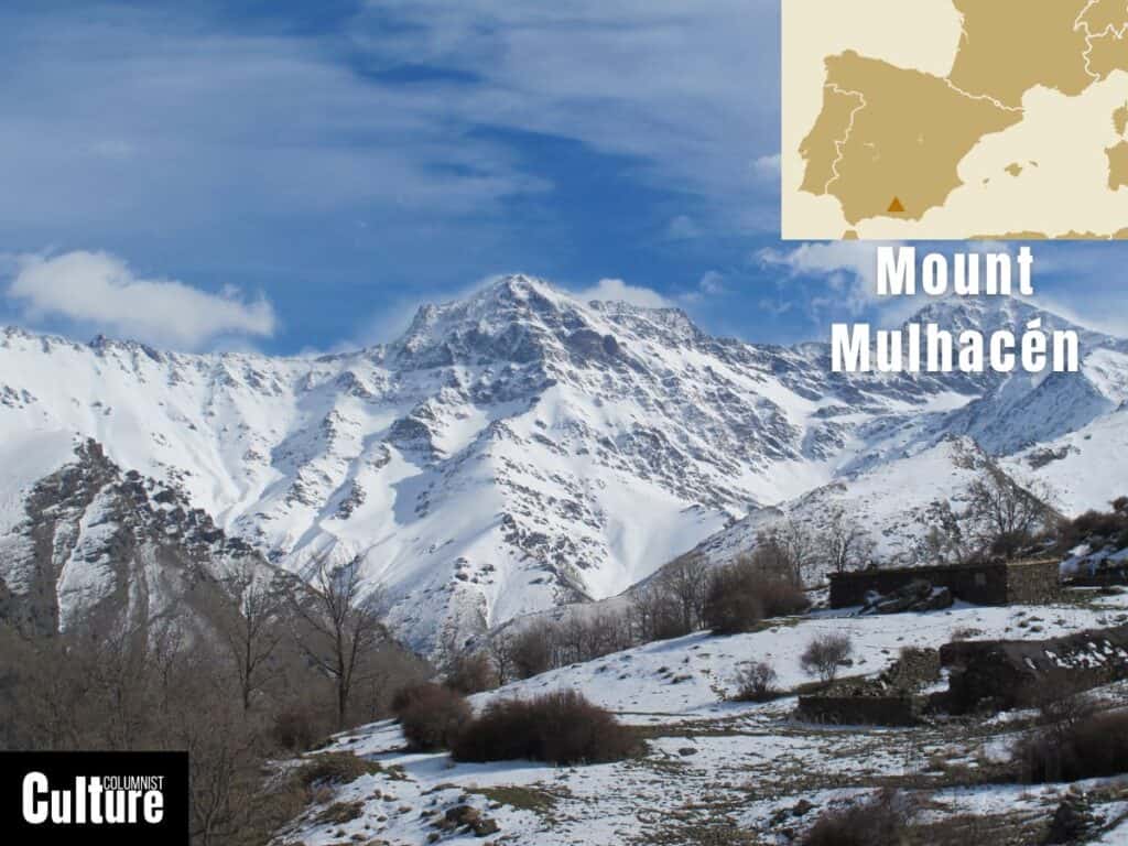
Mount Mulhacén is located in the Sierra Nevada mountain range in the region of Andalusia, southern Spain. The mountain is named after Muley Abul Hassan, a 15th-century Nasrid king. On a clear day, the summit provides expansive views extending as far as the Mediterranean Sea and the Moroccan Atlas Mountains.
With an elevation of 3,479 meters (11,414 feet), it is the highest peak on the Iberian Peninsula and the second highest in Western Europe. The landscape is mainly rocky and barren, but many of the plants that do grow here are unique, like the Sierra Nevada Poppy, the Violeta and the Zamárraga. You are also likely to see the Sierra Nevada ibex roaming the mountain during your walk.
Mulhacén offers climbing routes for all levels of mountaineers: while hikers can opt for a leisurely walk via the gentle southern slope, known as ‘loma’ in Spanish, seasoned climbers can challenge themselves with the more demanding routes along its icy northern face. The hike can take two days if you plan to stay overnight in Refugio Poqueira or it can be done in a single day at a fast pace.
The closest big city to the mountain is Granada. From there, many buses will already take you some of the way up, like the ski town of Pradollano, which lies at 2100 meters or the Alpujarras, at 1200 meters, where many of the routes into the mountain start. From the whitewash village of Alpujarras, you can get a good view of the mountain’s gentle southern slope.
Mount Etna, Italy
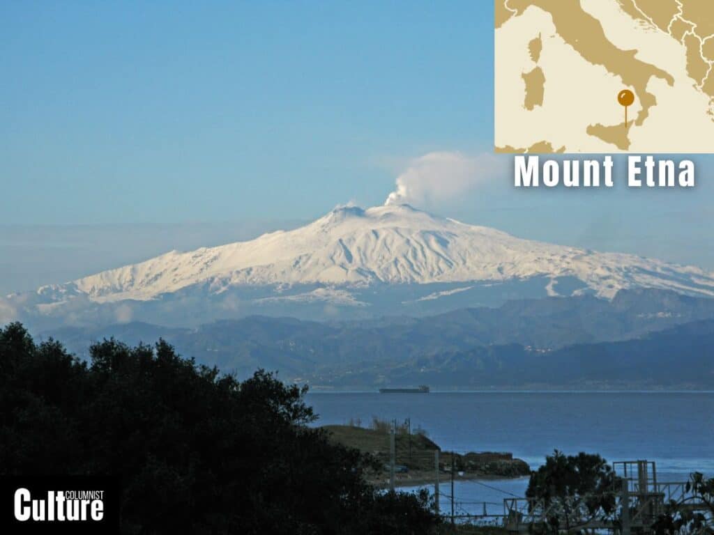
Mount Etna, situated on the east coast of Sicily in Italy, is the tallest active volcano in Europe and one of the world’s most famous volcanic landforms. Etna’s eruptions have been recorded since as early as 425 B.C., and its geological activity has helped to solidify its status as a UNESCO World Heritage Site.
Mount Etna is 3,329 meters (10,922 feet) in elevation, though this can vary due to its constant volcanic activity. Comprising mostly of stratovolcanic material, such as basalt and tephra, Etna’s landscape is continually reshaped by its frequent eruptions and exploring it is therefore dependent on safety conditions, so it is essential to go with a local guide who knows the area.
The two main routes to ascend Mount Etna include Rifugio Sapienza in the south, which is the most crowded thanks to its proximity to the main town of Catania, and the Piano Provenzana route to the north, which is on the wilder and quieter side of the mountain. Treks to the summit can take anywhere from a few hours to a full day. Technical mountaineering experience is not required but the trek is more challenging in the winter. Cable cars and off-road vehicle tours are available for those who prefer not to walk.
At the top of the mountain, you’ll not only see the views of the Sicilian landscape but also the Valle del Bove, a large depression with a diameter of about 32 kilometers (20 miles) caused by a collapsed crater. Due to the prominence of Mount Etna’s silhouette, on clear days, you can see the peak of the mountain from over 250 kilometers (155 miles) away.
What is the most mountainous country in Europe?
Switzerland is the most mountainous country in Europe, with 70% of the national territory covered by mountain ranges, including the Alps and the Jura. The Alps cover roughly 58% of the country, and the Jura 11%. It has 49 mountain peaks that are 4,000 metres or higher and is often referred to as the “Land of the Alps.”
While other countries like Austria, Italy, and France also boast significant portions of the Alps, and nations like Norway and Spain have their own impressive mountain ranges (the Scandinavian Mountains and the Pyrenees, respectively), Switzerland stands out for its sheer concentration and prominence as a mountainous region in Europe.
What are the three tallest Alps in Europe?
The Mont Blanc in France, standing at 4,808 meters (15,774 feet), is the tallest peak in the Alps; the Monte Rosa massif in Switzerland has the Alps’ second-highest peak, Dufourspitze, reaching 4,634 meters (15,203 feet); and Dom in Switzerland is the third-highest peak in the Alps at 4,545 meters (14,911 feet).
Mont Blanc is often mistakenly referred to as the highest peak in Europe, likely due to its prominence and fame. While the majority of the Mont Blanc massif, including the summit, lies in France and is the highest mountain in the Alps and Western Europe, it is only the 8th tallest mountain in Europe.